

Longs Peak Trail

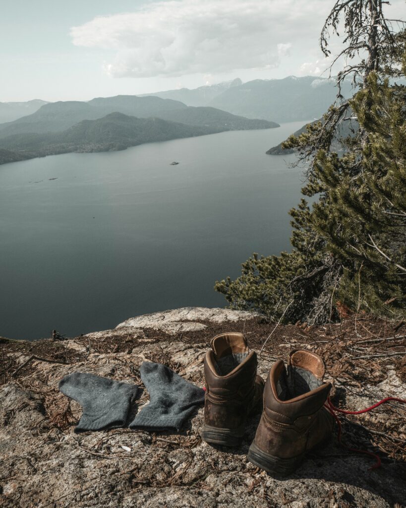
Longs Peak Trail in Rocky Mountain National Park welcomes hikers with its stunning grandeur and breathtaking views. Longs Peak, the park’s highest peak at 14,259 feet, is one of Colorado’s most sought-after mountains. Its dominating skyline draws explorers from far and wide to test their mettle on its steep slopes.
Longs Peak Trail is distinguished from other Colorado treks by its tremendous elevation increase, panoramic views, and sense of accomplishment after summiting this huge peak. To cross its harsh terrain and unpredictable weather, the path requires stamina, determination, and courage. Hikers must be prepared for a physically and mentally demanding excursion on steep inclines and exposed hills.
The beauty and sense of success of summiting Longs Peak Trail make it worth the trials. Hikers pass through pine woods and wildflower-filled alpine pastures. As the route climbs, craggy peaks and flowing waterfalls create a raw natural beauty.
Many hikers consider the Keyhole Route, a short tunnel through a rocky cleft to the top, the highlight of the Longs Peak Trail. This stretch of the route requires cautious navigation and fortitude to navigate its exposed ledges and tremendous drop-offs. Those who endure the Keyhole Route will be rewarded with stunning vistas of the Rocky Mountains and a sense of satisfaction from climbing one of Colorado’s most difficult peaks.
Longs Peak Trail showcases Colorado’s natural heritage as well as its stunning landscape and difficult terrain. Adventurers may see marmots, bighorn sheep, and the rare Rocky Mountain goat. Interpretive signs on the area’s geology, flora, and animals enhance the hiking experience and cultivate a respect for nature.
No description of Longs Peak Trail would be complete without addressing hiker friendship. Whether offering words of encouragement on the way or sharing stories and experiences at the peak, people who brave this epic trip feel connection. Finally, it’s about the trip and the ties made along the way, not simply the summit.
Maroon Bells Scenic Loop

The Maroon Bells Scenic Loop, a 1.9-mile route in the White River National Forest in Aspen, surrounds Maroon Lake and offers breathtaking vistas of the two spectacular peaks that reach over 14,000 feet. Deer, elk, and black bears can be seen as the route winds through wildflower-filled alpine meadows and fringes Maroon Lake.
The Maroon Bells Scenic Loop is one of Colorado’s top treks due to its accessibility and diversity. Many high-altitude paths need steep ascents, but this circular track is flat and ideal for all ages and ability levels. The Maroon Bells are accessible to families with small children, senior nature lovers, and casual hikers without particular gear or expertise.
Maroon Bells Scenic Loop offers a range of activities year-round, making it worth visiting at any season. Wildflowers line the route in summer, while the neighboring peaks give pleasant mountain winds. Aspen orchards turn golden in autumn, giving a postcard-perfect setting against the rocky Alps. The Maroon Bells’ calm magnificence draws snowshoers and cross-country skiers to its virgin slopes in winter.
Maroon Bells Scenic Loop offers calm and seclusion that is unusual in today’s congested world, in addition to its natural beauty and accessibility. Despite its popularity, the trail’s capacity is carefully regulated to retain its natural aspect, allowing people to enjoy nature without contemporary distractions. The Maroon Bells Scenic Loop is a great place to relax and reconnect with nature.
The Maroon Bells Scenic Loop provides outdoor lovers several recreational activities in addition to its beauty and accessibility. Beyond the circular path, the region has several hiking trails, from easy strolls to difficult alpine ascents. Backpackers may explore the Maroon Bells-Snowmass Wilderness for days, while rock climbers can test their abilities on the granite walls around the Bells. Fishermen may fish Maroon Lake’s clean waters for trout, while photographers can capture the landscape’s ever-changing moods.
Hanging Lake Trail

Hiking Hanging Lake Trail is like entering a nature postcard. The trailhead at Glenwood Springs along Interstate 70 gives breathtaking views and an opportunity to connect with nature. Hikers are met by a variety of views and sounds that inspire peace and amazement.
The trail’s beauty and moderate yet rewarding challenge make it appealing. The trek is feasible for hikers of all ability levels at slightly under 3 miles round-trip. The trail winds through a lush canyon with vivid vegetation, providing a magnificent backdrop.
Bridal Veil Falls is a Hanging Lake Trail feature. These delicate waterfalls cascade down canyon sides, enchanting hikers with their beauty and tranquility. Crystal-clear water cascading over moss-covered boulders sets the stage for the trail’s major feature.
After switchbacks and wooden boardwalks, trekkers reach Hanging Lake, a magnificent site. among a hidden basin, this pure alpine lake sparkles like a pearl among the emerald trees. Lakes fed by cold waterfalls and springs have an ethereal blue color.
Travertine formations in Hanging Lake accentuate its ethereal appeal. These limestone deposits create a fantasy novel-like environment. Hikers are awestruck by the peaceful rivers and beautiful foliage.
Hanging Lake is culturally and ecologically significant as well as beautiful. The lake, a National Natural Landmark, shows the necessity of protecting delicate ecosystems. Visitor restrictions include sticking on pathways and not touching the delicate travertine formations to preserve this wildness.
Hikers often travel to Hanging Lake to connect with the Colorado wilderness. Adventurers share smiles and support on the path, forming relationships beyond language and culture. Whether hiking alone or with others, Hanging Lake Trail leads to self-discovery and regeneration.
Garden of the Gods Loop
The Garden of the Gods Loop offers a rare chance to see nature’s beauty. This amazing climb begins with towering red rock formations that stand as ancient sentinels against beautiful skies. These massive sandstone monoliths, carved by wind and water over millions of years, form a bizarre environment.
Accessibility makes the Garden of the Gods Loop appealing. This path is ideal for families, solitary hikers, and experienced outdoor enthusiasts since it meets all ability levels, unlike some Colorado walks. Well-maintained trails weave around the park, giving modest inclines and stunning views. The Garden of the Gods Loop is energizing and accessible for a leisurely stroll or a heart-pounding climb.
This walk in Colorado is unique due to its geological heritage. Each rock structure reveals the prehistoric forces that created the terrain millions of years ago. From towering spires to delicate arches, the Garden of the Gods showcases nature’s majesty and beauty. Hikers can’t help but marvel at these geological wonders as they walk the path.
Besides its geological significance, the Garden of the Gods Loop has a varied flora and fauna. Many regional plant and animal species live in the park. Every turn holds unexpected discoveries, from colorful wildflowers to rare creatures. Birdwatchers will love seeing eagles, hawks, and other birds flying overhead, while nature lovers will marvel at this rough landscape’s rich ecosystems.
The Garden of the Gods Loop’s unequaled calm and quiet may be its most convincing justification for being one of Colorado’s top hikes. Despite its popularity, the park seldom seems crowded, enabling hikers to enjoy the scenery. A deep sense of tranquility fills the air while you’re basking in the warm glow of the sunrise or marveling at the blazing hues of the sunset, making it simple to forget about daily life and enjoy the moment.
Hikers will discover stunning overlooks with panoramic views of the surrounding area as they travel the path. From the renowned Siamese Twins to the beautiful Kissing Camels, these natural monuments provide great photo ops and calm reflection spots. The Garden of the Gods’ diversified topography and enchantment are revealed from each angle.
Chicago Lakes Trail

The Chicago Lakes Trail in the Mount Evans Wilderness southwest of Denver is 9 miles round trip. After the Mount Evans Scenic Byway, its trailhead is near Echo Lake Park. Hikers enter a peaceful world as they pass through lush pine and fir forests, the aroma of evergreens penetrating the cool mountain air.
As hikers climb the path, they have a view of spectacular mountain peaks, including Mount Evans at over 14,000 feet. The road winds beside babbling brooks and tumbling waterfalls, giving hikers plenty of chances to relax and enjoy nature.
Two magnificent alpine lakes set in challenging terrain are a highlight of the Chicago Lakes Trail. Lower and Upper Chicago Lakes are the hike’s crown jewels, each with its distinct appeal. Upper Chicago Lake, hidden in a glacier cirque, is stunning, while Lower Chicago Lake’s peaceful waters mirror the neighboring hills.
The trail’s varied environment, from wildflower-filled meadows to snow-covered rocky outcrops in summer, draws hikers beyond the lakes. This unspoiled environment is home to bighorn sheep, mule deer, and even black bears.
Accessibility and adaptability make the Chicago Lakes Trail one of Colorado’s top treks. The path is moderately difficult for hikers of all ability levels, but its closeness to Denver makes it a great day excursion for locals and visitors. The route provides an immersive outdoor experience that builds a profound respect for nature, whether you’re exploring alone or with friends and family.
Additionally, the Chicago Lakes Trail provides unlimited exploration and adventure. Hikers can continue their trek by connecting to the Summit Lake Trail or Mount Evans Summit Trail for a more challenging climb. Echo Lake’s surroundings provide picnics, fishing, and animal viewing, making it a great weekend retreat.
The Chicago Lakes Trail showcases Colorado’s wildness to outdoor lovers seeking Rocky Mountain adventure. Colorado’s greatest walks are made memorable by its pure alpine lakes, dramatic mountain panoramas, and diverse ecosystems.
Mt. Elbert Trail

Hikers are drawn to Mt. Elbert in the Sawatch Range in Leadville for its rough beauty and natural treasures. Hikers and mountaineers take pride in climbing Mt. Elbert, the highest peak in the Rocky Mountains and the second-highest in the contiguous US. This dramatic trek into the skies begins at the 10,000-foot trailhead.
Accessibility and variety make the Mt. Elbert Trail one of Colorado’s top treks. While tough, the path is accessible to hikers of all ability levels and offers day- and multi-day choices. Its well-defined road winds through deep forests, over alpine meadows with vivid wildflowers in summer, and ascends beyond the treeline to provide stunning views of the surrounding peaks and valleys.
Alpine landscape distinguishes the Mt. Elbert Trail. Hikers have panoramic views of the rocky Sawatch Range, with glistening lakes and snow-capped summits. The trail’s steady rise lets hikers adjust to the altitude while taking in the stunning scenery. The walk is enhanced by sightings of marmots, pikas, and bighorn sheep.
However, climbing Mt. Elbert is difficult. While well-maintained, the path climbs almost 4,000 feet from the trailhead to the top. Above the treeline, hikers must expect unexpected storms and severe winds. A safe and pleasurable hike requires strong hiking boots, warm clothes, enough of water, and a map and compass or GPS device.
Despite the hurdles, reaching the pinnacle is unmatched in satisfaction. Hikers feel wonder and admiration for nature when they reach Colorado’s highest mountain, surrounded by boundless skies and towering peaks. The summit provides breathtaking 360-degree views of Mt. Massive, the Collegiate Peaks, and Pikes Peak on clear days.
Many hikers see the Mt. Elbert Trail as a spiritual trek to connect with nature and push personal limits. Walking the route alone or with friends and family creates lifelong memories of friendship and adventure.
Royal Arch Trail

The Royal Arch Trail, a four-mile round ride in Boulder’s Chautauqua Park, offers thrills throughout. It draws hikers of all abilities, from novices to experienced mountaineers, as one of Colorado’s best. Starting softly, the walk winds through a pine grove that gives summer shade. Though peaceful, the trail steepens as you go, requiring physical and mental strength.
Over 1,400 feet of elevation rise make the path stand out. Hikers get a heart-pumping exercise and stunning views of Boulder and the Rocky Mountains on this trek. Expect rough switchbacks and thin mountainside ledges along the route. While difficult, each step gets you closer to the Royal Arch, a beautiful sandstone creation that gently spans overhead, framing stunning valley vistas.
As you reach the arch, you feel accomplished. Standing under its towering span or admiring it from afar, the Royal Arch is a tribute to nature’s force and tenacity. Hikers often halt here to enjoy the moment and reflect on their trek to this stunning location.
The Royal Arch Trail is a physical challenge and a tour of Colorado’s natural beauty. Hikers can see ponderosa pines, Douglas firs, and rare mountain species. Mule deer, Abert’s squirrels, and even black bears are rare, but they remind you of the untamed splendor around you.
Besides its natural beauty, the Royal Arch Trail shows Colorado’s geological past. Over millions of years, wind and water carved the area’s sandstone formations, producing a unique environment. Look at the intricate rock formations as you trek, each layer revealing a narrative of ancient oceans and changing tectonic plates.
No Royal Arch Trail talk would be complete without noting its breathtaking vistas. Hikers have stunning views of Boulder and the Flatirons from the arch. On a clear day, snow-capped peaks and limitless blue sky are visible for kilometers. It’s a postcard-perfect sight of Colorado’s natural splendor.
Grays and Torreys Peak Trail

Grays and Torreys Peak Trail in the Arapaho National Forest is a classic Colorado hike. This renowned path attracts hikers trying to summit Grays Peak, 14,278 feet, and Torreys Peak, 14,275 feet. These summits in the Front Range of the Rocky Mountains provide breathtaking views of the nature to adventurous hikers.
Accessibility and diversity distinguish Grays and Torreys Peak Trail from other Colorado treks. Locals and travelers love the trailhead’s easy access, an hour from Denver. Hikers quickly enter a rough environment with towering peaks, rich woods, and crystal-clear alpine lakes despite its proximity to the city.
Wildflower-filled alpine meadows in summer and a snow-covered winter wonderland in winter make the path a tribute to Colorado’s natural splendor. The well-maintained road leads hikers up steep switchbacks and rocky terrain to the thrilling summit push.
Hikers ascend Grays Peak to observe rocky ridges and jagged summits, while Torreys Peak gives panoramic vistas. After reaching the peak, trekkers are awestruck by the Rocky Mountains’ grandeur.
Beyond its physical difficulty and natural splendor, Grays and Torreys Peak Trail provides seclusion and peace in the outdoors. The flutter of the wind through the trees, the chirping of birds, and the distant rumbling of tumbling waterfalls replace the distractions of daily life as hikers reach the peak.
Grays and Torreys Peak Trail offers thrills and excitement. The trail’s difficult terrain and high height test even the most experienced hiker’s physical and mental endurance. With effort and determination, hikers can reach the peak, feeling accomplished and appreciating nature.
Along with its hard terrain and spectacular surroundings, Grays and Torreys Peak Trail has a rich biological tapestry of flora and wildlife. The path showcases Colorado’s diverse ecology, with wildlife and nature photography possibilities from delicate alpine flowers to secretive mountain goats.
Grays and Torreys Peak Trail also embodies Colorado’s hiking culture’s adventure. Hikers love the outdoors and want to challenge themselves to try new things, whether they trek alone or in a group. The trail’s transformation of strangers into friends with a similar objective shows nature’s power.
Flatirons Vista and Doudy Draw Loop

Locals and visitors adore the Flatirons Vista and Doudy Draw Loop in Boulder County, only a short drive from Denver. This fairly difficult 3.7-mile circular path lets hikers appreciate Colorado’s natural splendor while working out.
The scenery makes this climb appealing. Hikers see the Flatirons rock formations towering above the Rocky Mountains as they walk the path. These massive sandstone slabs, formed by millions of years of geological processes, always amaze.
But the Flatirons Vista and Doudy Draw Loop’s splendor goes beyond its famous rock formations. Hikers see everything from wildflower-filled meadows to deep woods full of animals. The route passes through ponderosa pine and aspen woods, giving nature enthusiasts plenty of chances to see deer, birds, and other animals.
The hike’s broad viewing spots give stunning views of the landscape. Hikers may see Colorado’s craggy hills, jagged peaks, and lush valleys for miles from these vantage spots. It’s a postcard sight that encapsulates Rocky Mountain life.
Flatirons Vista and Doudy Draw Loop are known for their natural beauty and cultural and historical significance. Indigenous peoples viewed the region as holy and mystical. Visitors may still feel the land’s deep connection to its original people as they explore the trail’s historic rock formations and religious locations.
Accessibility may make the Flatirons Vista and Doudy Draw Loop most appealing. This path is near metropolitan centers, making it accessible to hikers of all ages and abilities, unlike other of Colorado’s more rural trails. This path has something for everyone, from experienced hikers to first-timers seeing Colorado’s natural beauties.
The mild complexity of the trip makes it perfect for families, solitary hikers, and four-legged friends. Hikers may enjoy the views and sounds of nature with well-maintained routes and adequate signs.
For extra outdoor activity, the Flatirons Vista and Doudy Draw Loop offers lots of exploration and excitement. Side paths off the main loop lead to hidden jewels like Eldorado Canyon State Park or Marshall Mesa, where hikers may find private picnic places, calm streams, and secret waterfalls.
Black Canyon of the Gunnison Trail

Colorado has several beautiful hiking paths, each with its own character. Outdoor enthusiasts love the state’s Rocky Mountains and alpine lakes. Among these many possibilities, the Black Canyon of the Gunnison Trail is a must-see for hikers seeking excitement and stunning views.
Dramatic landscapes and unmatched wildness distinguish the Black Canyon of the Gunnison Trail. The Gunnison River carved the canyon over millions of years, demonstrating nature’s might. Black and red rock streaks decorate precipitous cliffs that drop hundreds of feet into the abyss. Shadowy canyon depths provide mystique to the scenery.
The walk runs along the canyon wall, affording stunning vistas at every bend. Visitors may see the canyon’s craggy rocks and flowing river from high viewpoints. The canyon glows orange and scarlet at sunrise and dusk when the sun illuminates the stony cliffs.
The Black Canyon of the Gunnison Trail is more than skin-deep beautiful. An abundance of vegetation and animals awaits behind its rocky façade. Hikers may see arid cactus and exquisite blooms on canyon sides. Mule deer, bighorn sheep, and golden eagles are plentiful in the canyon.
The Black Canyon of the Gunnison Trail is not for the fainthearted. Even experienced hikers struggle with the trail’s steep, rocky terrain and abrupt drop-offs. However, those who climb its heights reap tremendous rewards. Each stride along the canyon rim celebrates the irrepressible spirit of adventure and the many surprises that await those who go off the usual path.
For many hikers, the Black Canyon of the Gunnison Trail is best for its seclusion. The canyon is less developed than other of Colorado’s most popular hiking locations, enabling tourists to see nature at its purest. Hikers may escape the daily grind and reconnect with nature in the canyon’s calm.